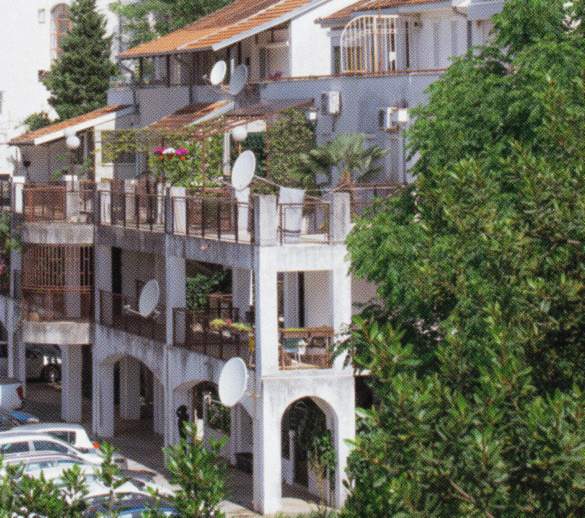

+ Podgorica – (eng. lit. 'Under the Hill of Gorica') is the capital and the largest city of Montenegro, with the geographical location at the base of several hills and rivers. It became the capital of Montenegro after World War II, when the city, then Titograd, underwent significant development and expanded rapidly to accommodate an increasing population and the demands of modernization.
+ Malo Brdo Hill – (eng. lit. 'Little Hill') is one of the five most significant hills in Podgorica. Located in the northeastern part of the city, the area of Malo Brdo Hill is predominantly populated with illegally built housing. Despite this, it is a popular spot for hiking, offering scenic routes and panoramic views of the city.
+ Momišići – is a city zone situated at the foothills of Malo Brdo. The initial detailed urban plan for this area was adopted in 1976, recognizing the potential of the natural landscape between the hill and the Morača River, and its proximity to the city centre. However, development did not follow the plan, and it still represents an informal zone of construction.
+ Malo Brdo neighbourhood – is a residential complex consisting of four buildings, constructed in 1993 by architect Aleksandar Keković and his team. The neighbourhood is located in the northernmost part of the detailed urban plan for Momišići and represents the only buildings completed according to the plan from 1984.
+ City Kej – is a residential complex consisting of three buildings, constructed in 2019 by private investor Čelebić Group. Located across the Morača River from the Malo Brdo neighbourhood, City Kej is roughly equidistant from the city centre. During the sales period, this neighbourhood was advertised as a luxury district, with a promised riverside promenade that has yet to be built.
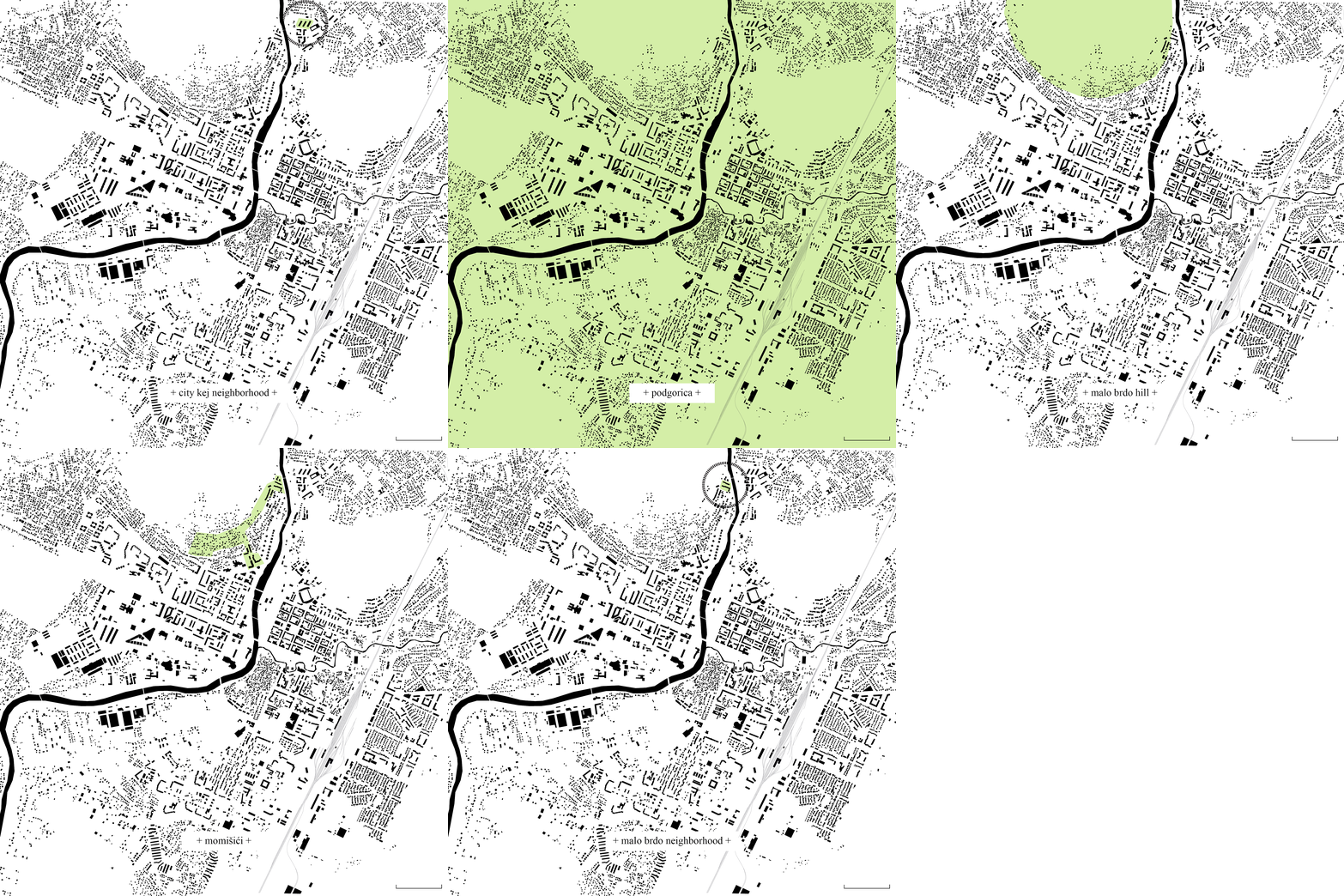 Figure 1. Spatial Glossary. Illustration done by the author.
 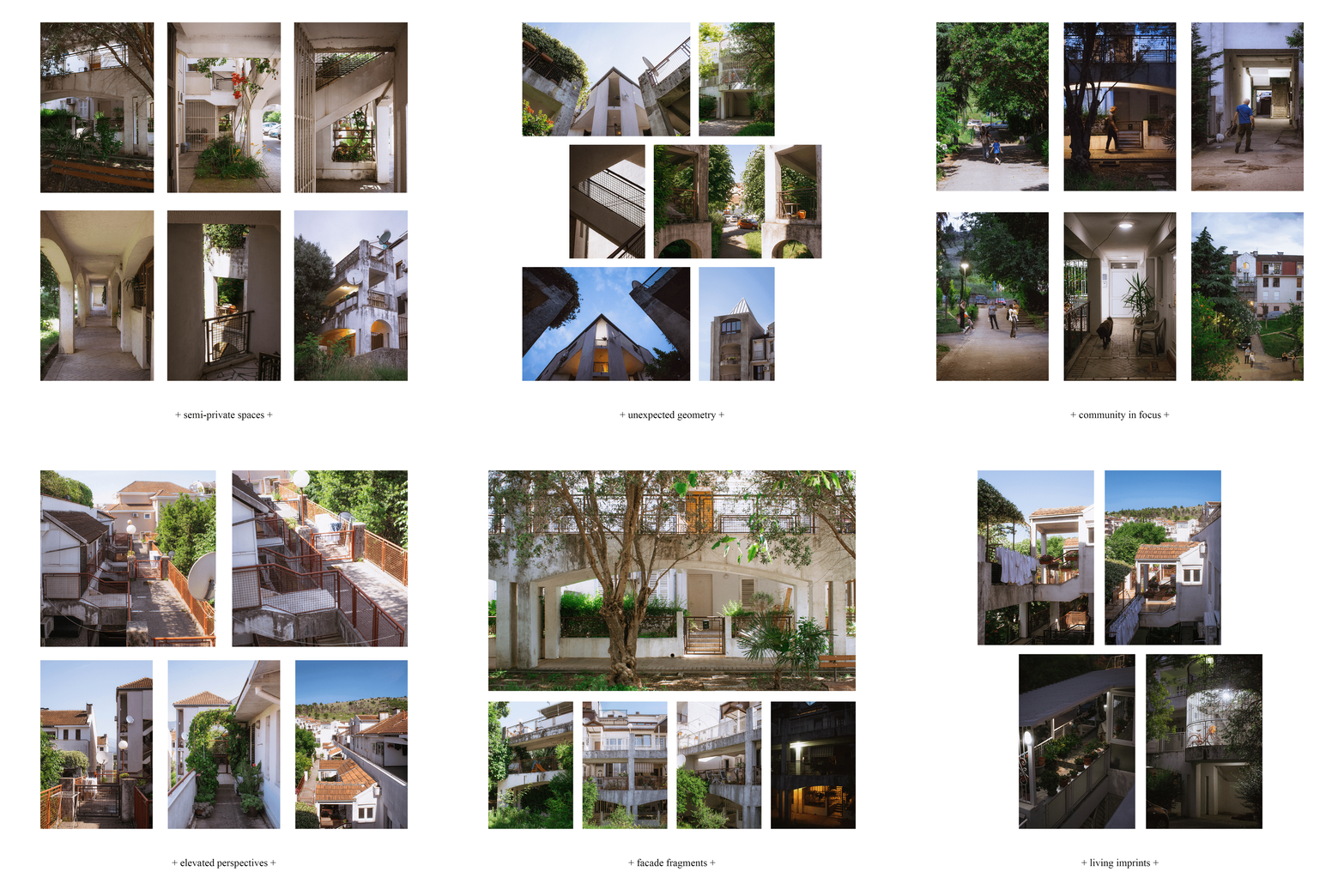 Figure 2. Photographs of the research site taken by the author.
After the Berlin Congress and the end of the Ottoman period (1878), Podgorica experienced a period of growth and prosperity, becoming part of Montenegro and beginning to embrace the stylistic characteristics of European architecture (Zejnilović & Husukić, 2019). The city started to expand intensively beyond its old core, and the previously organic street network was replaced by an orthogonal street grid, which became the foundation for the city's further development (Popović, Vlahović, & Lipovac, 2016).
During World War II, Podgorica was bombed multiple times, with over 60% of buildings destroyed and more than 96% damaged (Perović & Bajić Šestović, 2019). After the war, Podgorica underwent a period of urban expansion and economic boom, changing its name to Titograd. Under the strategy of the Socialist Federal Republic of Yugoslavia, it began an intensive development as the capital and socio-economic, cultural, and commercial centre of the Socialist Republic of Montenegro. Poor housing conditions, industrialization, and an increased influx of residents from other municipalities led to the need for rapid construction of collective housing (Alihodžić, Vučković, & Ašanin, 2019).
Intensive housing construction in Montenegro began in the early 1960s. Housing policy and the construction of new settlements in Montenegro followed federal housing policy, with slight delays due to slower capacity for construction. Most of the new housing buildings took place on the right bank of the Morača River - ‘New town’. The buildings had a modernist-functionalist style, flat roofs, and cubic masses (Stamatović Vučković, Bajić Šestović, & Bojović, 2019). Space was considered one of the most valuable resources, integral to the state's existence. Urban planning and design were approached responsibly and strictly, with space intended to valorize the social values of equity and equality, and it was proclaimed that state property was the property of all residents (Bojović & Bajić Šestović, 2020). The basic unit of city planning was a residential block – the neighbourhood.
Neighbourhoods were designed to provide residents with a high quality of life, meeting all their needs, and emphasising spaces for quality leisure time (Piskuric, 2022). Through SIZ (Self-Managing Communities of Interest), representatives of citizens – users of apartments – and representatives of social enterprises jointly decided on the locations, quality, quantity, and price of residential building constructions (Bojović & Bajić Šestović, 2020). Urban planners and architects adopted a modernist approach in the city's post-war reconstruction, focusing on functionality and simplicity in construction, materials, and building processes. This resulted in the creation of large public spaces, wide boulevards, and communal areas within buildings. Large-scale residential projects became the norm, characterised predominantly by standardised, prefabricated construction methods that enabled the rapid development of entire neighbourhoods. During this period, the foundations of most neighbourhoods in Podgorica were created, epitomising social housing through their visionary design.
After the breakup of the Socialist Federal Republic of Yugoslavia in 1992, Montenegro, as part of the republic community of Serbia and Montenegro, experienced the consequences of regional conflicts and went through a difficult period of hyperinflation. A decade spent with a weakened state apparatus and economic crisis has resulted in the degradation of spatial planning in Podgorica (Komatina, Kosanović, & Aleksić, 2016). These processes only continued after gaining independence in 2006. The systematic transformation from socialism to capitalism led to deindustrialization, where the working class and their needs were no longer the priority of city planning. Instead, capital became the focus, evidenced by the emergence of shopping centres and other commercial facilities as significant landmarks (Vujisić & Krklješ, 2020). Parallel to these processes, changes in the system led to the privatisation of space and a lack of state control over property. Private investors became a relevant factor in the urban planning and architectural design process, with a noticeable absence of a broader strategy (Komatina, Kosanović, & Aleksić, 2016).
Today (Figure 3), over three decades since the fall of communism and nearly two decades since regaining independence, Podgorica struggles to complete its transition and establish a clear urban development and housing strategy as a contemporary city. It lacks a response to the private use of public space and the absence of an aesthetic direction dictated by the capitalist mode of planning (Zejnilović & Husukić, 2019). Residential buildings, as well as public buildings from the socialist Yugoslavia era, still represent the most representative and attractive structures in the city.
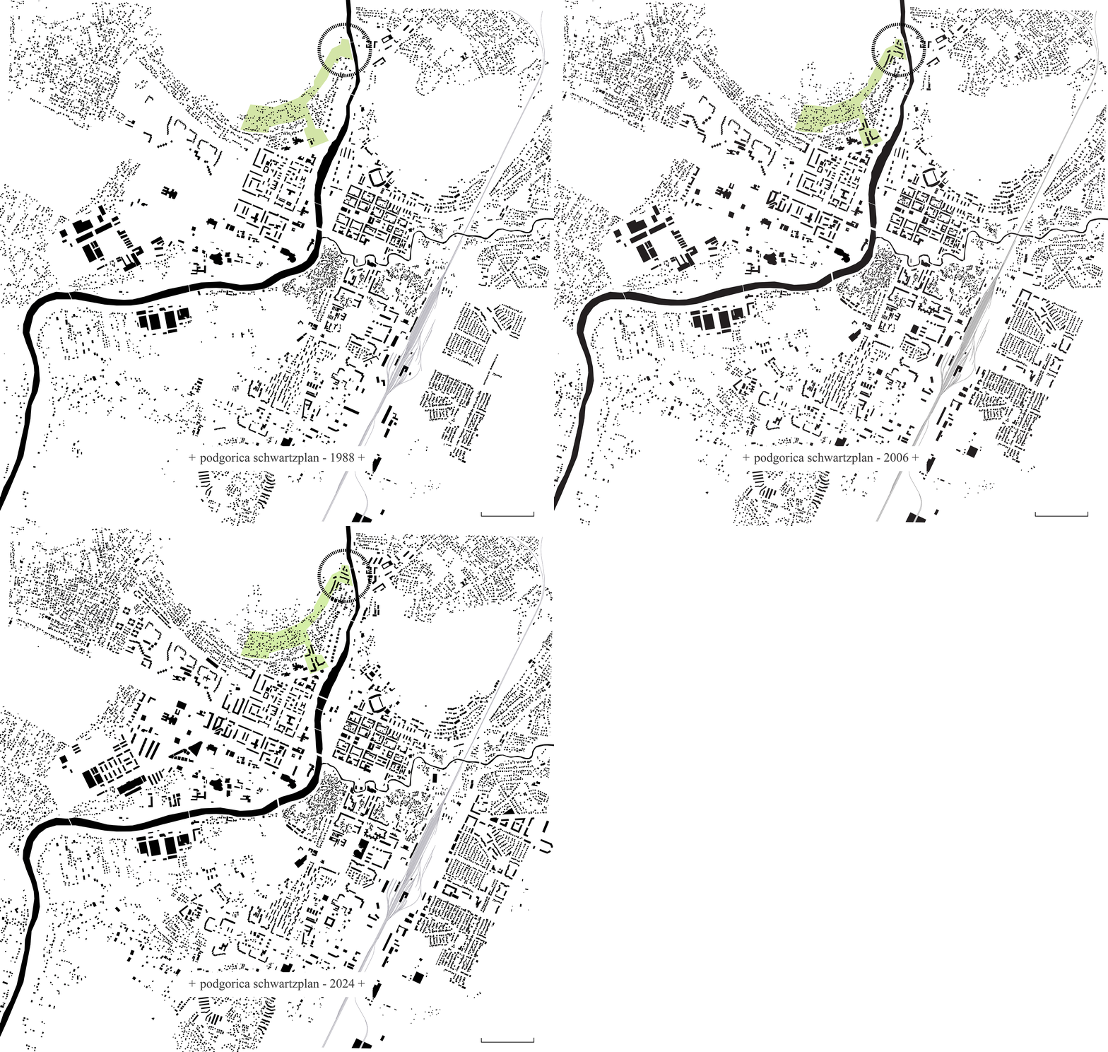 Figure 3. XXL scale - Podgorica schwartz plan comparison 1988 vs 2006 vs 2024. Illustration done by the author.
In the area of Malo Brdo hill, in the northern part of central Podgorica, along the Morača River, the first fortifications appeared during the Ottoman period. After the Berlin Congress and the rapid expansion of the city, residential settlements, characterised by spontaneous development, began to emerge at the foot of the hill, named Momišići (Urbanistički Institut SR Slovenije, 1989).
According to the General Urban Plan of Titograd from 1974, the area of the Detailed Urban Plan Momišići 'A' (Figure 4) was designated as a residential zone with accompanying amenities, covering an area of 79.6 hectares. The first Detailed Urban Plan was developed in 1976, with a revision in 1984. Although there was already a partially built residential fund in this area, mostly consisting of illegal and irregular constructions, the plan successfully proposed a solution that respected the specific geomorphological characteristics of the area. Given that this area bordered a forest to the north, the proposed concept emphasised connecting the city's activity axes with the natural environment and the terrain's morphology. Vital traffic flows were radially linked with the penetration points to the inner part of the zone, and recreational areas were organised at the interface with the existing forest area (Republički Zavod za Urbanizam i Projektovanje - Titograd, 1984).
However, the urban plan was not implemented as intended, and the number of illegally constructed buildings continued to grow (Komatina, Kosanović, & Aleksić, 2016). Consequently, implementing this Detailed Urban Plan would have required drastic measures to demolish almost the entire existing residential stock. The only structures built according to the 1984 detailed urban plan were collective housing complexes – Malo Brdo in the northern part of the area and buildings in the central part of the area.
Currently, the entire zone is characterised by these illegal individual housing structures, with uneven stories, sizes, and aesthetics. The roads are undefined and discontinuous (Ministarstvo ekologije, prostornog planiranja i urbanizma – Vlada Crne Gore, 2022). The current detailed urban plan does not foresee any optimistic changes that would improve this zone, except for emphasising the process of legalising informal structures and improving the existing technical infrastructure.
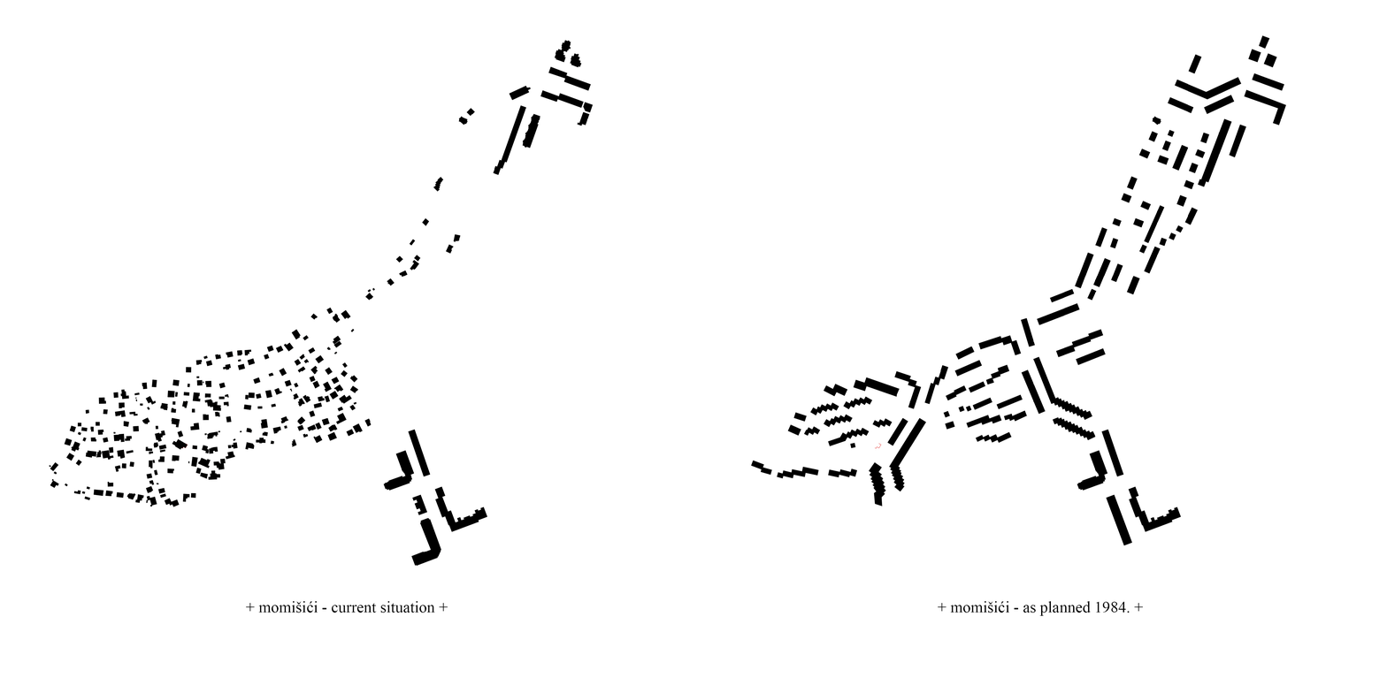 Figure 4. XL scale - Detailed Urban Plan Momišići ‘A’ - as planned 1984. vs 2024. situation. Illustration done by the author.
One of the two districts developed according to the Detailed Urban Plan of 1984, fully implemented as planned, is the residential complex Malo Brdo, located in the northern zone of Momišići, between the slopes of Malo Brdo hill and the Morača riverbed. The project for this complex was carried out between 1990 and 1991 (Alihodžić, 2015), and was designed by Aleksandar Keković,1 in collaboration with architects Nikola Drakić2 and Svetislav Popović.3 The residential complex consists of four buildings, counting around 250 apartments of various configurations.
Nikola Drakić, member of the design team for this project and lead of the team that worked on the Detailed Urban Plan of 1984, concluded that the project involved complex consideration of locational issues.4 The constructed buildings are only part of a project that envisaged additional structures that were never realised. According to the authors, this is the first architectural project printed and technically packaged in a modern way.5
The buildings were designed at the very end of the socialist era and the socialist approach to design, yet they better represent its principles than many other districts in Podgorica. Given that the location is at the very edge of the populated zone, at the beginning of the Malo Brdo forest, the transition was achieved by integrating vegetation between the buildings. Additionally, considering that the buildings were surrounded by individual houses at the time of construction, there was an evident effort by the architects to bring collective housing more similar to the individual, so that residents could enjoy the benefits of both housing concepts in one place. Although the complex borders a very busy road, it completely excludes active traffic. The arrangement of the buildings forms public spaces filled with green areas and parking spots (Figure 5).
What sets this complex apart from all others in Podgorica is the characteristic architectural typology of accessing individual apartments using gallery access/external decks typology.6 This approach achieved the effect of a house with a garden – that is, a gradation of open space privacy, from the public space belonging to the entire district, to semi-private horizontal communications that belong to the residents of one building, and finally to fully private open spaces, in the form of terraces accessed from the open galleries, leading into individual units. Residents of ground-floor apartments enjoy a special quality of living, as they have private yards with private gardens in front of and behind their residential units.
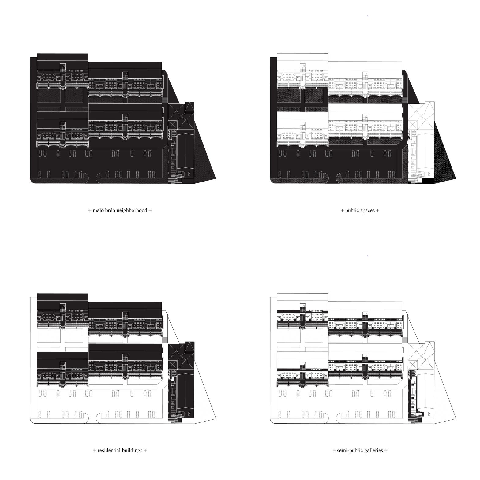 Figure 5. L scale - Malo Brdo Neighborhood’s elements. Illustration done by the author.
When observing the buildings of the Malo Brdo complex, due to the adaptations made by the residents and the slight unevenness of the terrain, the façades appear like a collage and are not clearly readable. Only by dissecting the elements present on the façade can one perform an analysis. The primary façade of the building is characterised by simplicity, rhythm, and monumentality, which are the main attributes of socialist architecture (Ašanin, 2016). Around this façade, a gallery extends, providing access to the residential units. The secondary layer of the façade consists of terraces with their gates, which on higher floors also feature roof coverings. The tertiary façade layer, the access gallery, is the most visible element and gives the buildings their distinctive character. It consists of long horizontal walkways supported by arches. The author's inspiration for this approach could have been the typology of Montenegrin houses, characteristic of the Montenegrin karst region, which had open staircases and terraces supported by massive multi-part arches called 'volat' (Rajković, 2012). Additionally, the presence of arches, along with vegetation and traces of everyday life (clotheslines, children's toys, outdoor furniture), reveals characteristics of Mediterranean architecture (Zoranić, 2012).
When analysing the visual perception of the Malo Brdo complex, the appearance of a regular rhythm7 on the façade is evident, forming a segment (a) consisting of an arch with supporting pillars and railings, along with the primary façade featuring four equal openings at equal distances. This segment of repetition is interrupted by vertical communications (b) (Figure 6). In the two largest buildings of the complex, there is also a staggered arrangement, leading to the expansion of public space with an amphitheatre.
As a landmark8 in the physical structure of the neighbourhood, a pyramidal glass element on the building at the corner stands out. This entire building differs from the others by its smaller plan dimensions, different application of the gallery typology (communications are located at the corner of the building), absence of arches, but also by the presence of the pyramidal glass part on the corner of the building's roof. Additionally, this building has housed the “Most” art gallery on the ground floor for over 30 years, which is why the entire neighbourhood is often colloquially referred to as 'the neighbourhood where the “Most” gallery is located'.
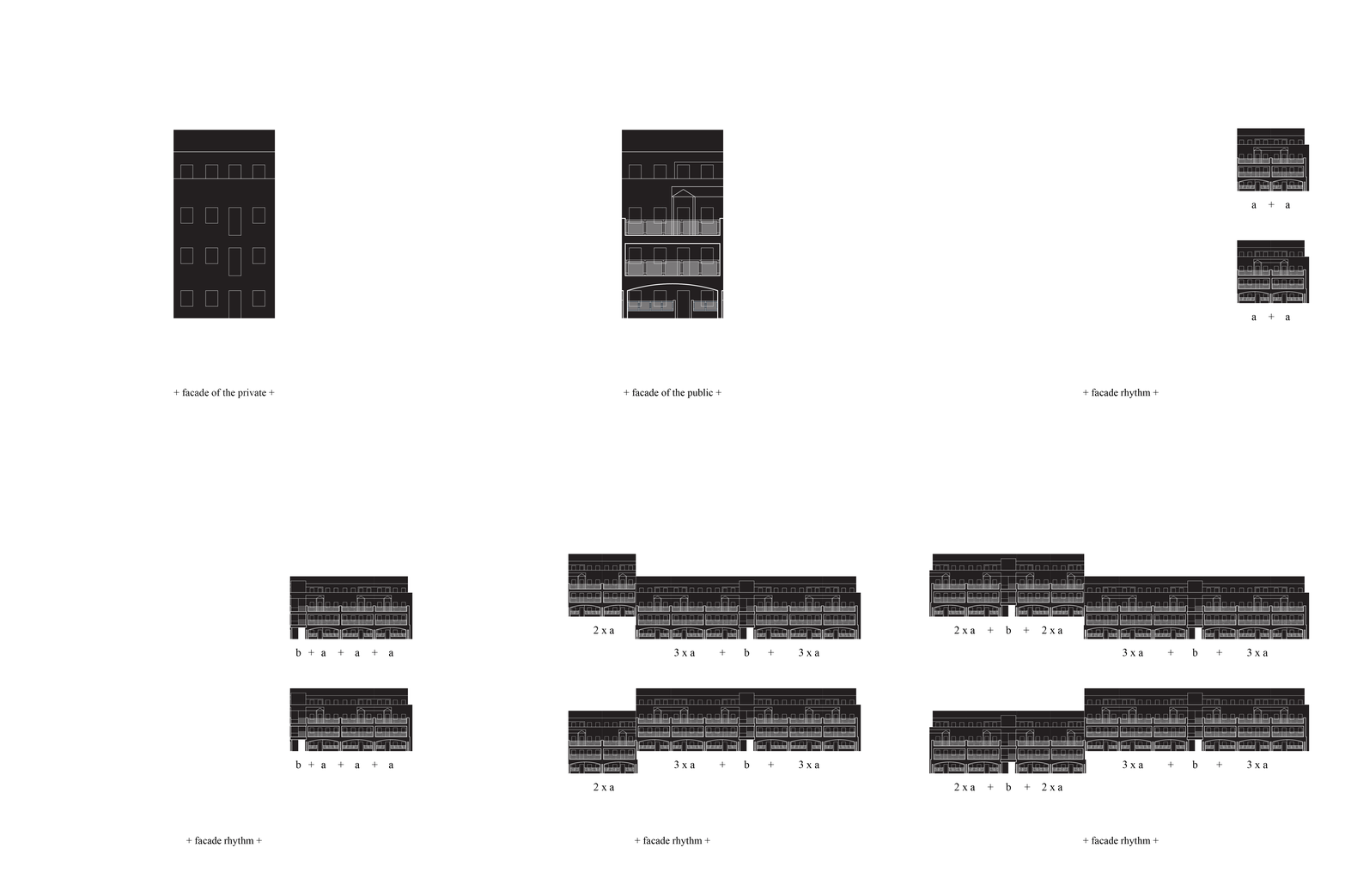 Figure 6. M scale - Façade’s segment’s layering and façade rhythm analysis. Illustration done by the author.
The buildings contain apartments of various layouts: studio apartments, one-bedroom, two-bedroom, and three-bedroom units (Figure 7). Most apartments have undergone interior and exterior modifications, making it difficult to determine their original layout in the absence of original technical drawings. The most desirable units are those on the ground floor, as each features private open gardens at both front and back of the apartment. The gardens at the front are about 3,5 metres long, while the back garden is 6 metres long. Ground-floor apartments are two-bedroom, around 75 square metres, with clearly separated living and sleeping areas. From the interview with team member Nikola Drakić,2 it was revealed that the apartments were not fully constructed according to the original project. The ground-floor apartments were intended to include saunas, and some even a winter garden, which was uncommon for apartments in the country.
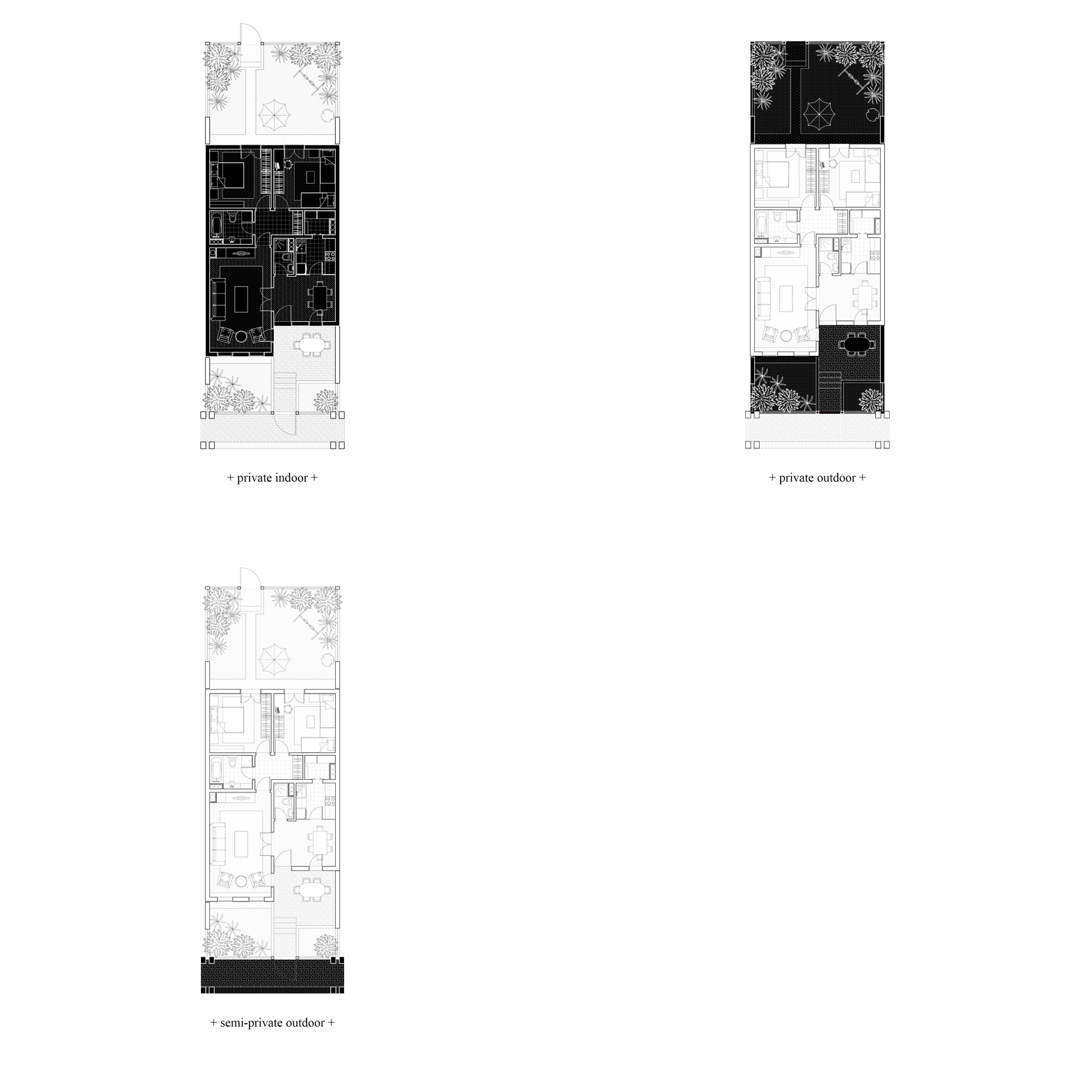 Figure 7. S scale - Analysing the spaces of ground floor residential units. Illustration done by the author.
What gives authenticity to this neighbourhood are the evident traces of use by residents, as well as modifications they have made to their apartments. The most significant alterations include the addition of rooms in garden and terrace areas, as well as the construction of steel barriers around their terraces to ensure privacy and security, indicating potential issues residents may have faced in the past.
To gain insight into residents' experiences living in the Malo Brdo residential complex, a questionnaire9 was distributed covering various aspects of living quality related to the living space. To better understand the factors affecting the quality of living in this neighbourhood, an equal number of questionnaires were also given to residents of the City Kej10 complex, located across the Morača River.
The survey results (Figure 8) indicate that the Malo Brdo complex is rated significantly higher in terms of satisfaction with private and public spaces, open areas, and a sense of community.11 However, it is rated lower in terms of security and the presence of additional amenities such as shops, restaurants, and pharmacies. In addition to individual responses, the comparative results from the questionnaires provide insight into the differences between socialist and capitalist housing concepts, as well as the effects of gallery typology on the sense of community and security.
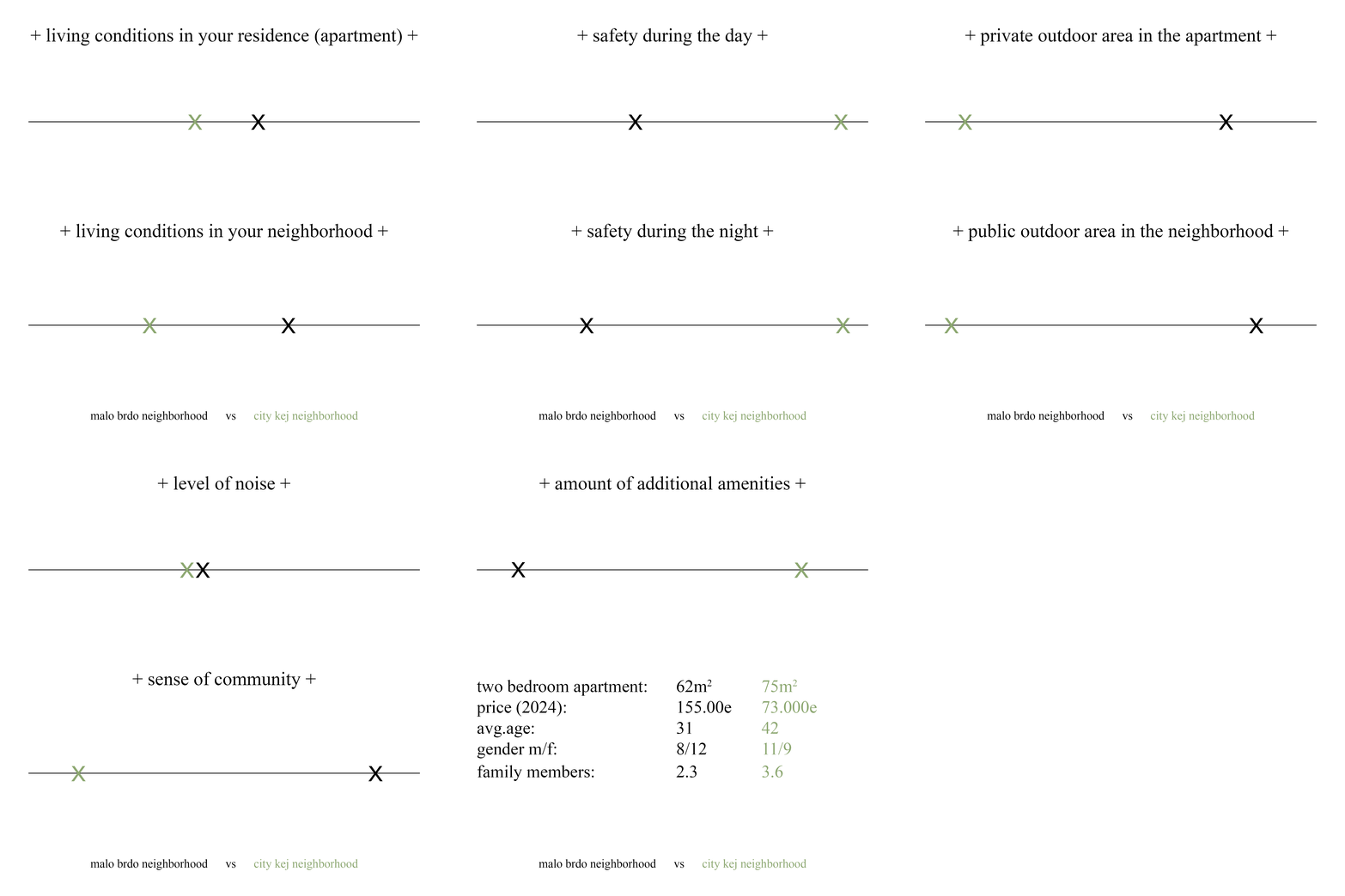 Figure 8. Visual representation of the questionnaire results in Malo Brdo and City Kej neighbourhoods. Illustration done by the author.
September 2024, Montenegro
Get updates from balkan story map.
Building bio
NEIGHBOURHOOD BIO
Name of the building: Malo Brdo Neighbourhood
Former name of the building/neighborhood: N/A
Current Address/District: Lamele Malo Brdo/ Street Serdara Jola Piletića
Period of design:1991-1992
Period of construction:1993-1994
Author/Architect/s/Urban planner: Aleksandar Keković, Nikola Drakić, Svetislav Popović
Institution/Architectural studio: Republički zavod za urbanizam i projektovanje Titograd
Construction company: no information
The number of buildings: 4
Number of apartments: cca. 250